
Storm King Mountain
- Aug 29, 2021
- 5 min read
Updated: Sep 3, 2021
A lower Hudson Valley region hike in New York that offers great views and complements Breakneck Ridge from across the Hudson River on the west bank.

About The Hike
Storm King Mountain is located in Storm King State Park, south of the town, Cornwall-on-Hudson. The park features an art center with giant field sculptures and a network of hiking trails. The park has two summits, Storm King Mountain, and less popular, North Point Summit. What makes this hike a local favorite is ample viewpoints from the trail, rock vistas, and the summit. The trail network loops around the top of the mountain creating views to the north, east, and west overlooking the Hudson River and lower Hudson Valley.


There are several parking lots to access this hike with Route 9W being the most popular. This is the starting point for a loop trail between 2.5 and 3.5 miles depending on which trails you ultimately use for each section. Storm King Mountain has many intersecting trails so be prepared with your map of choice, I prefer to use AllTrails for the ability to download and show GPS location on the map while I’m hiking.
When hiking from Route 9W parking you do have an option to take the white trail on the right rather than the orange trail on the left. This will give you a more relaxed hike, however, you will be hiking through the woods and miss out on some of the best views before reaching the summit. If looking to decide which trail to take up, Butter Hill on the map is a false summit that you reach early on and has great views (this is where the cover photo was shot). This is what I and most others would recommend, especially if this is your first-time hiking Storm King.
Storm King Mountain Loop:
Distance: 3.2 Miles
Type: Loop
Elevation: 1348 feet
Ascent: 1102 feet

My Bear Story
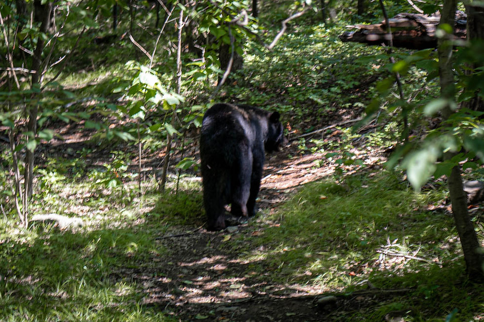
I summited Storm King Mountain shortly after 12 o’clock on a hot and humid summer day in August. I was heading over to hike Breakneck Ridge after this so I began to rush the descent as my excitement for this next hike grew. The summit area of Storm King is light on elevation but has a couple rock boulders that you maneuver over and around. With my excitement to get down quickly I was skipping and hopping around this section with a sharp curve in the trail when I landed on my feet, looked up, and saw I was standing 20 feet! Yes, 20 freaking feet! Away from a full-grown black bear, walking towards me!
It took longer than it should have for me to process, so as I stand there with my feet planted and my mind in a boggle trying to contemplate what is going on, the bear is still lumbering towards me. At this same point, I and the bear, realize we do not want to make a pass on the other and he calmly, and slowly makes a 180-degree turn and begins to slumber back the way he came.
With myself in total shock with this extremely rare occurrence (in 2,200 miles of my recent Appalachian Trail hike I never came close to a bear encounter like this) and noting that I was safe standing where I was currently at, I began to fumble around for my camera. Luckily for me, I always hike with my camera on my Peak Design Camera Clip making it a mere second to access and turn on for a shot. After a couple shaky and far off photos were had, I ended up seeing the bear off over a hill and continuing down the mountain.
I reached two older woman hiking up several minutes after the encounter and had informed them of this incredible news, more as a noteworthy and exciting story than a warning because the bear was long gone, but if in strange case he stayed around, this information doubling as a warning was a good thought too. These women hadn’t been able to hear what I said when I told them about my ‘massive bear’ encounter and waited until I shut up to ask, “a massive what?” in which I replied “oh! Well, a bear!”.
At this point their faces went white with terror in which I begun to instantly offer my trust in the safety of the situation and the remote chance they would experience any kind of encounter themselves. For a second though I thought they were going to turn around and cling to me for protection the whole way down!
Sometimes we forget that we share the forest with animals that are bigger than us and especially in places that are this close to highways and civilizations. Let it be a reminder to always be alert and know what to do in such situations, luckily this was the best outcome to be had.

Storm King Highway
If you’ve never driven this highway, be sure to check it out when heading out even if it’s out of the way. This road is super unique with winding curves that hug the rock cliffs of the mountain that you just climbed. There is a small turnoff that can fit a few cars where the train tracks below cut through a cove in the Hudson. The views from here look directly at Breakneck ridge and the rest of the Hudson Highlands. It’s also a great place to watch the freight trains thunder through the mountain and down the side of the Hudson.


Getting There and Important Information
The main parking lot is located on Route 9W, which by design has long stretches without exits and may require a few miles of doubling back on Route 9W if coming from the north. The parking lot here has no amenities and the trail is typically dry so be prepared with enough water before reaching the parking lot. The trail is a mix of forest and short rock scrambles with exposed summit areas, pack accordingly for a variety of trail conditions.
If you have any questions or enjoyed this bizarre bear story drop a comment below!
This post contains affiliate links. If you use these links to buy something we may earn a commission. Thanks!
©Copyright 2020-2021 Secret Hike
Photography exclusively by Dan Oliver unless otherwise stated and cited. Embedded maps are provided by Embed Google Map (embedgooglemap.net) and map images shown are provided as stated and cited.
DISCLAIMER:
This website is provided for entertainment purposes only, and is not meant to serve as an instructional guide, or present itself as an authority for any of the locations written about. The locations mentioned, written, and photographed herein are nothing more than my personal adventure archive. If you are interested in visiting any locations you should not depend on the information in this website to plan any excursions. You should research a wide variety of informational sources, websites, hiking guide books and maps found elsewhere. Many locations are dangerous and potentially illegal to access which can lead to fines, injury or death even when prepared. I do not encourage anyone to trespass or put themselves or others in way of harm. This website, and therefore its’ owner/author, cannot assume any responsibility for anything you may incur while hiking or exploring any of these locations or anywhere on planet earth. Thank you for viewing!


I really enjoyed your bear story !! I'd appreciate knowing when it happened (date ?) . I had a nearly identical bear encounter on 5/25/24 when i was in the woods about 1/4 mile south of SK . Simce bears have home ranges , i tend to think its the same bear . Mine was a full grown , BIG male . And he scared me so bad i froze in terror and even screamed . Im so ashamed. But he was peaceful and wandered off into the brush , thank God . Like you , hiking for decades , put in lots of miles , but was never face to face with a bear , till a few mo…